![](/images/other/stat-length.png)
![Tocht Stappen Gorges du Tarn Causses - Champerboux_La Rouvière_ Les Dolmens_16,7km - Photo](https://media.geolcdn.com/t/1900/400/ext.pjpeg?maxdim=2&url=https%3A%2F%2Fstatic1.geolcdn.com%2Fsiteimages%2Fupload%2Ffiles%2F1553511878bg_sport_marche.png)
Champerboux_La Rouvière_ Les Dolmens_16,7km
Pousscailleux
Gebruiker
![Lengte](/images/other/stat-length.png)
Lengte
16,7 km
![Max. hoogte](https://static1.geolcdn.com/siteimages/upload/files/1508320355ic_sort_altitude_max_24dp.png)
Max. hoogte
951 m
![Positief hoogteverschil](https://static1.geolcdn.com/siteimages/upload/files/1508320355ic_sort_den_pos_24dp.png)
Positief hoogteverschil
281 m
![Km-Effort](/images/other/stat-length.png)
Km-Effort
20 km
![Min. hoogte](https://static1.geolcdn.com/siteimages/upload/files/1508320355ic_sort_altitude_min_24dp.png)
Min. hoogte
815 m
![Negatief hoogteverschil](https://static1.geolcdn.com/siteimages/upload/files/1508320355ic_sort_den_neg_24dp.png)
Negatief hoogteverschil
282 m
![Boucle](https://static1.geolcdn.com/siteimages/upload/files/16400158638029165_repeat_loop_refresh_sync_direction_icon.png)
Boucle
Ja
Datum van aanmaak :
2015-03-27 00:00:00.0
Laatste wijziging :
2015-03-27 00:00:00.0
![Stappen](https://static1.geolcdn.com/sitytour/trail-icons/101.png)
4h29
Moeilijkheid : Medium
![Scan deze QR-code om de tocht te openen in de SityTrail-applicatie](https://capi.geolives.com/qq0zvz2zws4bq2lad0pu/sitytour/trails/400635/qr.png?size=200)
Gratisgps-wandelapplicatie
Over ons
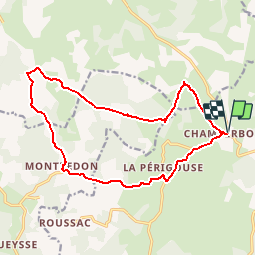
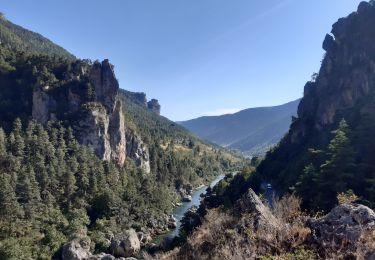
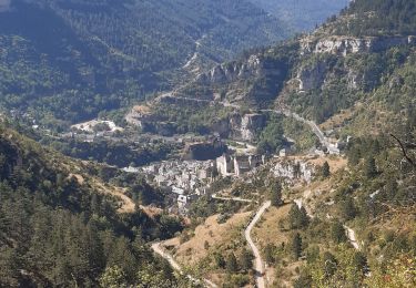
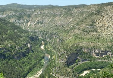
Tocht Stappen van 16,7 km beschikbaar op Occitanië, Lozère, Gorges du Tarn Causses. Deze tocht wordt voorgesteld door Pousscailleux.
Beschrijving
Départ de Champerboux.
Peu après Champerboux, le GR 60 est délaissé momentanément pour visiter le Puits de Fraisse au nord de la route. Le retour par Montredon et La Périgouse traverse une partie aride du Causse de Sauveterre.
Plaatsbepaling
Land:
France
Regio :
Occitanië
Departement/Provincie :
Lozère
Gemeente :
Gorges du Tarn Causses
Locatie:
Sainte-Enimie
Vertrek:(Dec)
Vertrek:(UTM)
532935 ; 4917431 (31T) N.
Opmerkingen
Wandeltochten in de omgeving
![Tocht Stappen Gorges du Tarn Causses - Ste Enimie, le Boisset - Photo](https://media.geolcdn.com/t/375/260/c8e7aa0f-2f81-400e-a6dd-e67c5f500e2c.jpg&format=jpg&maxdim=2)
![Stappen Stappen](https://static1.geolcdn.com/sitytour/trail-icons/101.png)
Ste Enimie, le Boisset
Stappen
Medium
Gorges du Tarn Causses,
Occitanië,
Lozère,
France
![](/images/other/stat-length.png)
8,4 km | 14,6 km-effort
2h 33min
![](https://static1.geolcdn.com/siteimages/upload/files/16400158638029165_repeat_loop_refresh_sync_direction_icon.png)
Ja
![Tocht Stappen Gorges du Tarn Causses - Tour du Causse Méjean - Etape 1 - Photo](https://media.geolcdn.com/t/375/260/ext.jpg?maxdim=2&url=https%3A%2F%2Fservices.sitytrail.com%2FGeolivesWS%2FDownloadMedia.ashx%3FTrailID%3D1037411%26Media%3Dfix__20180831135516.jpg)
![Stappen Stappen](https://static1.geolcdn.com/sitytour/trail-icons/101.png)
Tour du Causse Méjean - Etape 1
Stappen
Gemakkelijk
Gorges du Tarn Causses,
Occitanië,
Lozère,
France
![](/images/other/stat-length.png)
15,5 km | 22 km-effort
4h 36min
![](https://static1.geolcdn.com/siteimages/upload/files/16400158638029165_repeat_loop_refresh_sync_direction_icon.png)
Neen
![Tocht Stappen Gorges du Tarn Causses - Randonnée autour de Sainte-Enimie - Photo](https://media.geolcdn.com/t/375/260/ext.jpg?maxdim=2&url=https%3A%2F%2Fservices.sitytrail.com%2FGeolivesWS%2FDownloadMedia.ashx%3FTrailID%3D111759%26Media%3D8222_6.jpg)
![Stappen Stappen](https://static1.geolcdn.com/sitytour/trail-icons/101.png)
Randonnée autour de Sainte-Enimie
Stappen
Medium
(2)
Gorges du Tarn Causses,
Occitanië,
Lozère,
France
![](/images/other/stat-length.png)
7 km | 12,9 km-effort
3h 0min
![](https://static1.geolcdn.com/siteimages/upload/files/16400158638029165_repeat_loop_refresh_sync_direction_icon.png)
Ja
![Tocht Motor Gorges du Tarn Causses - Ste-Enimie - St-Rome - Photo](https://media.geolcdn.com/t/375/260/ext.jpg?maxdim=2&url=https%3A%2F%2Fstatic1.geolcdn.com%2Fsiteimages%2Fupload%2Ffiles%2F15247431544x4.jpg)
![Motor Motor](https://static1.geolcdn.com/sitytour/trail-icons/400.png)
Ste-Enimie - St-Rome
Motor
Gemakkelijk
(2)
Gorges du Tarn Causses,
Occitanië,
Lozère,
France
![](/images/other/stat-length.png)
36 km | 50 km-effort
Onbekend
![](https://static1.geolcdn.com/siteimages/upload/files/16400158638029165_repeat_loop_refresh_sync_direction_icon.png)
Neen
![Tocht Kanoën - kajakken Gorges du Tarn Causses - GR60 jour 8 Les Vignes - Photo](https://media.geolcdn.com/t/375/260/4666bd5a-fb1b-4da5-91d1-7868a4c22f75.jpg&format=jpg&maxdim=2)
![Kanoën - kajakken Kanoën - kajakken](https://static1.geolcdn.com/sitytour/trail-icons/703.png)
GR60 jour 8 Les Vignes
Kanoën - kajakken
Heel gemakkelijk
Gorges du Tarn Causses,
Occitanië,
Lozère,
France
![](/images/other/stat-length.png)
28 km | 38 km-effort
8h 57min
![](https://static1.geolcdn.com/siteimages/upload/files/16400158638029165_repeat_loop_refresh_sync_direction_icon.png)
Neen
![Tocht Stappen Laval-du-Tarn - GR60 jour 8 Sainte Enimie - Photo](https://media.geolcdn.com/t/375/260/93624a29-a49b-490a-93e7-5e13d6226025.jpg&format=jpg&maxdim=2)
![Stappen Stappen](https://static1.geolcdn.com/sitytour/trail-icons/101.png)
GR60 jour 8 Sainte Enimie
Stappen
Moeilijk
Laval-du-Tarn,
Occitanië,
Lozère,
France
![](/images/other/stat-length.png)
15,5 km | 19,3 km-effort
6h 10min
![](https://static1.geolcdn.com/siteimages/upload/files/16400158638029165_repeat_loop_refresh_sync_direction_icon.png)
Neen
![Tocht Stappen Gorges du Tarn Causses - st enimie - Photo](https://media.geolcdn.com/t/375/260/593157cb-56eb-4249-a5c6-f6ce93eff1f2.jpg&format=jpg&maxdim=2)
![Stappen Stappen](https://static1.geolcdn.com/sitytour/trail-icons/101.png)
st enimie
Stappen
Medium
Gorges du Tarn Causses,
Occitanië,
Lozère,
France
![](/images/other/stat-length.png)
7,1 km | 9 km-effort
1h 38min
![](https://static1.geolcdn.com/siteimages/upload/files/16400158638029165_repeat_loop_refresh_sync_direction_icon.png)
Ja
![Tocht Stappen Gorges du Tarn Causses - champerboux pessade - Photo](https://media.geolcdn.com/t/375/260/a96ed76f-5129-4c42-9c64-bd216df03975.jpg&format=jpg&maxdim=2)
![Stappen Stappen](https://static1.geolcdn.com/sitytour/trail-icons/101.png)
champerboux pessade
Stappen
Medium
(1)
Gorges du Tarn Causses,
Occitanië,
Lozère,
France
![](/images/other/stat-length.png)
8,3 km | 11 km-effort
2h 8min
![](https://static1.geolcdn.com/siteimages/upload/files/16400158638029165_repeat_loop_refresh_sync_direction_icon.png)
Ja
![Noords wandelen Noords wandelen](https://static1.geolcdn.com/sitytour/trail-icons/102.png)
Sainte-Enimie - L'ermitage
Noords wandelen
Heel gemakkelijk
Gorges du Tarn Causses,
Occitanië,
Lozère,
France
![](/images/other/stat-length.png)
1,8 km | 3,5 km-effort
1h 0min
![](https://static1.geolcdn.com/siteimages/upload/files/16400158638029165_repeat_loop_refresh_sync_direction_icon.png)
Ja